Current Weather
Temperature: 71 (f)
Barometric Pressure: 29.89 in (falling slowly)
Dew Point: 47 (f)
Wind Speed and Direction: 4 mph from the west
Currently there are multiple low pressure systems associated with a large frontal movement across much of the Midwest. Upper air data shows a slight ridge occuring in the jetstream for the great lakes region. The line of rain seen extending from Michigan to New York is likely due to a stationary front.
Monday, May 7, 2012
Wednesday, May 2, 2012
Current weather:
Temperature: 77 (f)
Barometric Pressure 29.77 in and stable
Wind speed and direction: calm
Dew Point 61 (f)

Temperature: 77 (f)
Barometric Pressure 29.77 in and stable
Wind speed and direction: calm
Dew Point 61 (f)
Today our area is experiencing very warm weather. A mid latitude cyclone continues to move through our region pulling warm southerly air across Wisconsin. Upper air data shows much of the Great Lakes region is in a small ridge in the jet stream adding to the warm temperatures. Thunderstorms occured last night as a result of a warm front associated with the mid latitude cyclone. I predict tomorrow's weather to be similar to today's with a slight chance a thunderstorms likely due to convective forces.

Tuesday, May 1, 2012
Current Weather
Temp: 74
Wind: South at 5 mph
Barometric Pressure: 29.79 in and dropping
Currently there is a large mid latitude cyclone stationed over eastern North Dakota. The Cyclone is drawing up warm humid air over Wisconsin causing warm weather. I predict this warm front will draw up small isolated thunderstorms throughout the day tomorrow.

Thursday, April 26, 2012

Wednesday, April 25, 2012
Eau Claire experienced some light rain this morning due to a low pressure system located in southern Minnesota. I expect the system to move through Wisconsin late this evening bringing fair weather.

Temperatures today ranged from the mid 50's to the mid 60's. Currently the wind is at 4 mph out of the east and barometric pressure is stable. Tomorrow's temperature is going to be slightly cooler with temperatures in the 50's. The reason for the drop in temperatures is the meridional jet stream that currently had our area and the western states in a ridge is now leveling out into a more zonal pattern.

The image above shows the visible spectrum in terms of cloud cover. As you can see there is a belt of clouds throughout the midwest associated with that low pressure system and accompanying stationary and warm fronts.
Tuesday, April 24, 2012
Temperature: 70 (f)
Barometric Pressure: 29.65 and falling rapidly
Wind Speed and Direction: Southwest 5 mph
Dew Point: 29 (f)
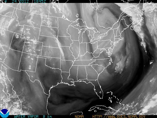
Currently there is a developing low pressure system over top of eastern South Dakota. This accounts for the recent drop in barometric pressure. I expect this system to make its way over Wisconsin sometime early tomorrow, bringing possibilities of showers.
 300mb pressure data shows a large trough extending through the Great Lakes region all the way down to Florida. This trough accounts for some of the rather cold and severe weather being experienced out east and the above average temperatures in the western states.

 The above image shows the amount of water vapor in the air. That line of water vapor extending over western Iowa and Missouri is a result of the low pressure system and warm front approaching our state.
Barometric Pressure: 29.65 and falling rapidly
Wind Speed and Direction: Southwest 5 mph
Dew Point: 29 (f)
Currently there is a developing low pressure system over top of eastern South Dakota. This accounts for the recent drop in barometric pressure. I expect this system to make its way over Wisconsin sometime early tomorrow, bringing possibilities of showers.


Tuesday, April 17, 2012

Subscribe to:
Posts (Atom)